

Geotechnical monitoring: ground and surroundings in view to the millimetre
We monitor excavations, slopes, tracks and adjacent buildings with automated total stations, GNSS and wireless sensors. The readings flow continuously into the online portal, and an alert follows if defined limit values are exceeded.
- Automated total stations
- Settlement and displacement in 3D
- Alerts on limit values
Your benefits
Detecting ground movement early and reliably
Anyone working in the ground changes its surroundings. Automated geotechnical monitoring shows how much, and gives everyone involved a shared data basis.
Request a quoteMeasurement around the clock
The total station measures automatically at a fixed interval, day and night. The interval can be adjusted remotely, without anyone having to be on site.
Three directions in one system
Settlement and horizontal displacement are recorded together at every prism. One measurement shows whether a point is sinking, tilting or moving sideways.
Self-referencing
Reference points outside the zone of influence check the station’s own position in every cycle. Real movement therefore stays distinguishable from movement of the station.
Sensors can be combined
Tilt, crack, vibration and groundwater sensors run on the same platform. All measured quantities of a site are in one place.
The basics
What is geotechnical monitoring?
Geotechnical monitoring is the instrumented monitoring of geotechnical assets, also known as geomonitoring. It records how ground, excavations, slopes and the structures within their zone of influence move. It is often part of the observational method under DIN EN 1997-1 (Eurocode 7), in which prediction, measurement and decisions during construction work together.
What is monitored
Ground, excavations and shoring, slopes and embankments, plus structures, tracks and utilities within their zone of influence.
What is measured
Displacement and settlement, plus tilt, crack width, vibration and groundwater level, depending on the task.
What for
Detecting changes early, checking limit values, alerting those responsible and documenting the trend without gaps.
Measuring with a total station
How an automated total station measures
A total station is a motorised surveying instrument. In monitoring, it targets prisms on its own and determines their position to the millimetre, cycle after cycle.
- 01
Baseline measurement
Before the works begin, the total station determines the initial position of all prisms. This is the reference for every later movement.
- 02
Check its own position
At the start of each measurement cycle, the station targets reference points outside the zone of influence and checks its location.
- 03
Target the prisms
It then measures all prisms on the structure, shoring, track or slope fully automatically and calculates their position in three directions.
- 04
Check the limit values
The readings are transferred automatically to the cloud and compared with the defined limit values there.
- 05
Alert and document
If a value is exceeded, an alert goes to the defined group of people. All readings are available in the online portal.
Measurement methods
Which method captures which movement
The total station is often the backbone. Depending on the task, we add sensors that record individual quantities continuously and densely.
| Method | What it measures | Typical use |
|---|---|---|
| Automated total station with prisms | Displacement and settlement in three directions at many points | Excavations, bridges, tracks, adjacent buildings |
| GNSS station | Position in three directions, also over large areas and without line of sight to a station | Slopes, landslides, dams |
| Distributed fibre optic sensing (DFOS) | Strain and temperature continuously along an optical fibre | Piles, embankments, dikes, tunnels |
| Tilt sensor | Tilt and the settlement derived from it | Retaining walls, buildings, masts |
| Crack and displacement sensor | Crack width and joint movement | Adjacent buildings, rock faces |
| Cable extension sensor | Deformation of rockfall barriers | Rockfall, slope protection |
| Vibration monitor | Peak particle velocity to DIN 4150-3 | Piling, drilling, demolition |
| Groundwater and water level sensor | Groundwater level and pore water pressure | Dewatering, excavations |
Applications
Where geotechnical monitoring makes the difference
Excavation
Excavations and shoring
Excavation and shoring change the ground around the site. Prisms on the shoring show its deformation in every construction phase.
Construction & developmentExisting structures
Adjacent buildings and bridges
Structures within the zone of influence are monitored for settlement and displacement, complemented by crack and vibration monitoring.
Bridge monitoringRailways
Tracks within the site
For works on or beneath railway assets, total station monitoring records the track geometry in line with the RIL requirements.
Track monitoringSlopes
Slopes, embankments and rock faces
Landslides and rockfall announce themselves through movement. Sensors on the rock and the barrier report events immediately.
Slopes & guardrailsIn practice · Railways
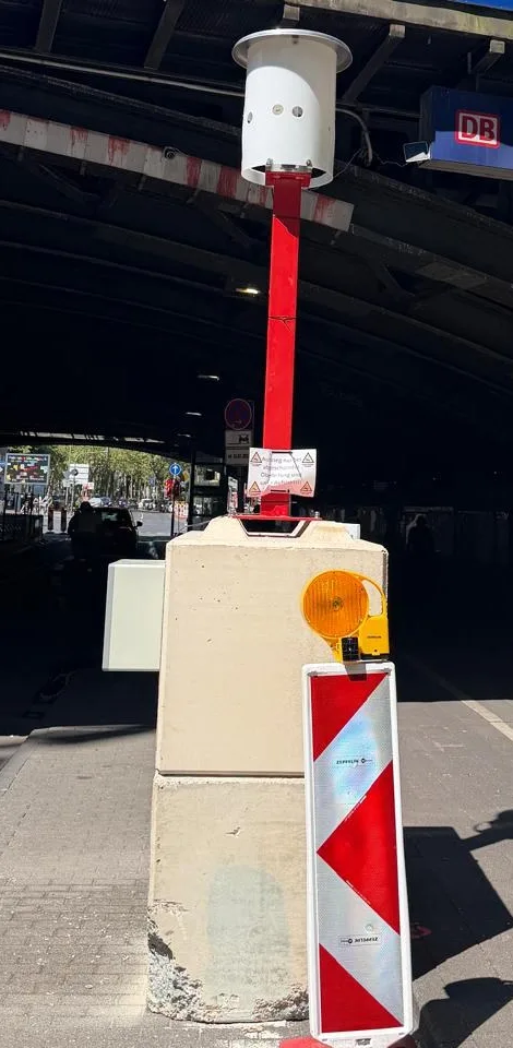
Railway bridge over Venloer Straße, Cologne
During works at the Hans-Böckler-Platz light rail stop, an automated total station monitors the railway bridge and the shoring of the construction pits: 27 prisms on the two abutments, measurement every 30 minutes, checks in the cloud and alerts when limit values are exceeded.
Ask about a similar projectIn practice · Slopes
Rockfall monitoring in the Middle Rhine Valley
Over 45 metres, two levels of a rockfall barrier at different heights are fitted with cable extension sensors, complemented by displacement transducers on the rock face above. If the barrier catches falling rock, the event is reported immediately.
View the referenceAll from a single source
From monitoring concept to alerting
We plan the geotechnical monitoring, install total stations and sensors, operate the system and evaluate continuously. One contact for the whole project.
- 01
Concept
We define measuring points, methods and limit values in the monitoring concept, matched to ground, construction sequence and requirements.
Learn more - 02
Installation
We set up the total station, reference points, prisms and sensors and carry out the baseline measurement.
Learn more - 03
Maintenance and operation
We keep the station and sensors ready for operation and adjust measurement intervals remotely if needed.
Learn more - 04
Monitoring and alerting
We continuously check the readings against the limit values and alert the defined group of people.
Learn more
Read more about settlement in our guide to settlement monitoring, and find an overview of all measured quantities under structural health monitoring.
Geotechnical monitoring for your site
Whether excavation, slope, track or adjacent building: we define measuring points, methods and limit values and monitor around the clock.
 Christian Steffes

Data platform
All readings on one platform
The sensors transmit their readings wirelessly to the data platform, where they are evaluated, documented and continuously checked against your thresholds.
- AI-assisted data analysis
- User-focused reporting
- Continuous evaluation
- Warning and alarm thresholds
- Alerts by email and text message
- Remote access around the clock
- AI-assisted data analysis Condition within limits
- User-focused reporting Report ready
- Alerting Thresholds monitored
Frequently asked questions about geotechnical monitoring
What is geotechnical monitoring?
How does monitoring with a total station work?
When is GNSS used instead of a total station?
How often does the total station measure?
How does geotechnical monitoring differ from structural health monitoring?
When is geotechnical monitoring useful?
Which limit values apply?
How am I informed if a limit value is exceeded?
Does a total station need power on site?
Project inquiry
Let’s talk about your site
Tell us about the construction works, the surroundings and the requirements. You will receive an initial assessment with suitable methods and measuring points shortly.
+49 6742 8599600 DE +41 41 670 00 11 CH [email protected]